Share Scenic Eastern Escarpment Upgrade on FacebookShare Scenic Eastern Escarpment Upgrade on X (formerly Twitter)Share Scenic Eastern Escarpment Upgrade on LinkedinEmail Scenic Eastern Escarpment Upgrade link
Consultation has concluded
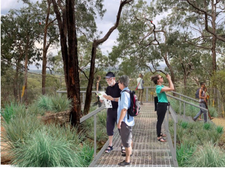
Significant upgrades are being made to the Scenic Eastern Escarpment. Located on the eastern edge of the Blue Mountains, stretching from Lapstone to Hawkesbury Heights and neighbouring Western Sydney, the precinct offers walking tracks and bike tracks through Blue Mountains bushland, and lookouts over the Nepean Gorge and Cumberland Plains.
Further remediation work underway at Lapstone Hill Tunnel
5 November 2024
Work to repair significant damage along the eastern cutting track, from Governors Drive, Lapstone to the eastern portal of Lapstone Hill Tunnel, is underway.
The eastern cutting track has been closed to the public since April, when successive storm events caused significant damage to the track surface and nearby Sydney Water infrastructure.
The work involves clearing rubble and other debris from the track before relaying the path’s surface, making it safe again for community access. Relaying the path's surface is the first step towards long term improvements to the eastern cutting track.
These works are expected to be complete in late November (weather permitting)
About the Scenic Eastern Escarpment upgrades
A $2 million upgrade to 2.35km of walking tracks in the lower Blue Mountains will make significant heritage features more accessible.
This project will not only make these walking tracks in the lower Blue Mountains more accessible to more people, but it will also help open up significant heritage areas.
The Blue Mountains is one of only two cities around the world that sit within a World Heritage Area. Increasing accessibility provides equal opportunity and access for all to enjoy the unique and diverse bushland that forms the Greater Blue Mountains World Heritage Area.
The Scenic Eastern Escarpment is an important regional recreational space with over 16km of bush trails. Council will be improving the safety and amenity of a number of shared walking tracks and trails, lookouts, steps and stairs within Knapsack Reserve, including:
Lapstone Zig Zag to Top Points Lookout
Marges and Elizabeth Lookouts
Elizabeth Lookout Track to Knapsack Bridge
Marges Lookout Track to Lennox Bridge
Lovers Walk to Mitchells Pass (Whitton Memorial Place)
Work on these is due to commence at various stages. Council will provide as much onsite notice to reserve users as is possible and will program works to be the least inconvenient to reserve users, providing detours as alternatives where feasible.
These improvements are in line with the Scenic Eastern Escarpment Masterplan adopted by Council in May 2018 after a year of extensive community consultation. The Masterplan guides future use of the Eastern Escarpment – and can be found via the following links:
You can read our FAQs (Frequently Asked Questions) to the right and follow the project, simply press the 'Subscribe' button.
Past project updates are also available in the News Feed below.
*The project will be funded under the Western Parkland City Liveability Program, which is part of the Western Sydney City Deal (WSCD). The WSCD is a 20 year-agreement between the Australian and NSW governments, and the eight local Councils of the Western Parkland City.
Share Lapstone Hill Tunnel: Community consultation report on essential and future design works on FacebookShare Lapstone Hill Tunnel: Community consultation report on essential and future design works on X (formerly Twitter)Share Lapstone Hill Tunnel: Community consultation report on essential and future design works on LinkedinEmail Lapstone Hill Tunnel: Community consultation report on essential and future design works link
Thursday, 11 July 2024
The community consultation report for the essential and future design works survey, which closed earlier this year, is now available.
Following significant progress on the restoration of the Lapstone Hill Tunnel, Council called for community feedback on a number of upgrades that must be completed before the tunnel can open for public use.
The report presents the community’s feedback that will inform ongoing project planning for the Lapstone Hill Tunnel project.
Share Lapstone Zig Zag Shared Path and Top Points Lookout upgrade is now open for the community on FacebookShare Lapstone Zig Zag Shared Path and Top Points Lookout upgrade is now open for the community on X (formerly Twitter)Share Lapstone Zig Zag Shared Path and Top Points Lookout upgrade is now open for the community on LinkedinEmail Lapstone Zig Zag Shared Path and Top Points Lookout upgrade is now open for the community link
28 March 2024
A range of accessibility upgrades to the Lapstone Zig Zag Track and Top Points Lookout are now practically complete and the popular walk is now open.
The upgrades include:
Transforming the Zig Zag track into an accessible, shared, asphalt pathway of approximately 850 metres running out to Top Points Lookout.
An accessible, elevated platform at the Top Points Lookout at the northern end of the pathway, which will provide views over the Cumberland Plain.
A formalised parking area in the Knapsack Street cul-de-sac providing five angled parking spaces, and including two accessible parking spaces, for the community.
Improved landscaping next to the parking area and trail head, including a small rain garden for stormwater treatment.
Seating at intervals along the pathway.
While Council has worked to ensure the Zig Zag Track and Top Points Lookout can reopen for Easter, there remain some minor landscaping improvements to be made in the weeks ahead.
Share Have your say on essential and future design works for the Lapstone Hill Tunnel on FacebookShare Have your say on essential and future design works for the Lapstone Hill Tunnel on X (formerly Twitter)Share Have your say on essential and future design works for the Lapstone Hill Tunnel on LinkedinEmail Have your say on essential and future design works for the Lapstone Hill Tunnel link
Survey closed.
Monday, 18 March 2024
Council is calling for community feedback on a series of essential upgrades and future design elements for the Lapstone Hill Tunnel.
Before the tunnel can be opened to the public, improvements to the tunnel’s drainage system need to be made, as well as the installation of lighting and electrical connections.
We are also calling on the community to consider:
How the cultural and heritage significance of the tunnel might be reflected.
Initial thoughts on a proposal for a bridge across Knapsack Gully near the western entrance of the tunnel.
Future opening and closing times for the tunnel.
This survey closed on Monday, 8 April 2024.
Following community feedback, installation of the drainage and lighting solutions, plus further minor repairs and remediation, is anticipated to be completed by the end of 2024.
Share Lapstone Zig Zag Shared Path and Top Points Lookout upgrade update on FacebookShare Lapstone Zig Zag Shared Path and Top Points Lookout upgrade update on X (formerly Twitter)Share Lapstone Zig Zag Shared Path and Top Points Lookout upgrade update on LinkedinEmail Lapstone Zig Zag Shared Path and Top Points Lookout upgrade update link
7 December 2023
Unfortunately, the opening of the accessible Lapstone Zig Zag shared path and Top Points Lookout upgrade has been delayed into early 2024 .
This is due to extensive delays in the supply chain and fabrication of necessary steel components for the upgrade of Top Points Lookout. This also has a flow-on impact for the work on the shared path. Heavy machinery needs to use the path to access the lookout and until the lookout work is completed, the surface of the path cannot be laid.
It is now anticipated that the Lapstone Zig Zag and Top Points Lookout accessibility upgrades will be completed in March 2024.
Currently, work is underway on repairs to the Northern and Eastern rock walls at Top Points Lookout.
Once completed, the upgrades will provide:
An accessible, shared, asphalt pathway approximately 850 metres long along the alignment of the existing Zig Zag Track to the Top Points Lookout.
An accessible, elevated platform at the Top Points Lookout at the northern end of the pathway, which will provide views over the Cumberland Plain.
A formalised parking area in the Knapsack Street cul-de-sac providing five angled parking spaces, and including two accessible parking spaces, for the community.
Improved landscaping next to the parking area and trail head, including a small rain garden for stormwater treatment.
Seating at intervals along the pathway
While this area remains closed to the public for a little longer than anticipated, completed upgrades to a number of shared walking tracks and trails, lookouts, steps and stairs within nearby Knapsack Reserve allow visitors to explore the fantastic bushland of the Scenic Eastern Escarpment. Recent upgrades include:
Marges and Elizabeth Lookouts
Elizabeth Lookout Track to Knapsack Bridge
Marges Lookout Track to Lennox Bridge
Lovers Walk to Mitchells Pass (Whitton Memorial Place)
We apologise for the delay to the Zig Zag and Top Points Lookout upgrades and appreciate the community’s patience as we work to complete the improvements.
Share Lapstone Zig Zag Shared Path and Top Points Lookout Upgrade commences on FacebookShare Lapstone Zig Zag Shared Path and Top Points Lookout Upgrade commences on X (formerly Twitter)Share Lapstone Zig Zag Shared Path and Top Points Lookout Upgrade commences on LinkedinEmail Lapstone Zig Zag Shared Path and Top Points Lookout Upgrade commences link
15 June 2023
From Friday, 16 June 2023 the Lapstone Zig Zag Walking Track and Top Points Lookout, as well as the end of the Knapsack Street cul-de-sac, will be temporarily closed to allow a range of upgrades to be made, including:
An accessible, shared, asphalt pathway approximately 850 metres long along the alignment of the existing Zig Zag Track to the Top Points Lookout.
An accessible, elevated platform at the Top Points Lookout at the northern end of the pathway, which will provide views over the Cumberland Plain.
A formalised parking area in the Knapsack Street cul-de-sac providing five angled parking spaces, and including two accessible parking spaces, for the community.
Improved landscaping next to the parking area and trail head, including a small rain garden for stormwater treatment.
Seating at intervals along the pathway
The track and lookout will remain closed while the upgrades are completed.
The work is expected to be finished late 2023 (weather permitting).
We thank the community for their patience as we work to deliver these important accessibility upgrades.
Share Update on Elizabeth Lookout on FacebookShare Update on Elizabeth Lookout on X (formerly Twitter)Share Update on Elizabeth Lookout on LinkedinEmail Update on Elizabeth Lookout link
Update on Elizabeth Lookout
April 2023
Elizabeth Lookout is planned to have new handrails installed.
A partial closure is required from Wednesday 26th April 2023 to end of July 2023 to allow for handrail replacement and lookout platform renewal works.
Update on Elizabeth Lookout
April 2023
Elizabeth Lookout is planned to have new handrails installed.
A partial closure is required from Wednesday 26th April 2023 to end of July 2023 to allow for handrail replacement and lookout platform renewal works.
Share Update on new accessible Zig Zag to Siding Lookout track on FacebookShare Update on new accessible Zig Zag to Siding Lookout track on X (formerly Twitter)Share Update on new accessible Zig Zag to Siding Lookout track on LinkedinEmail Update on new accessible Zig Zag to Siding Lookout track link
Update on new accessible Zig Zag to Siding Lookout track
September 2022
Improvements to Lapstone Zig Zag Walking Track to Siding Lookout have been delayed due to multiple natural disasters in 2020, 2021 and 2022.
The accessibility upgrade will provide a new inclusive experience for more members of the community and is one component of a $2 million upgrade to nearly two and a half kilometres of lower mountains walking tracks.
The Lapstone Zig Zag to Siding Lookout upgrade includes the construction of a new accessible pathway along the current track alignment, to an upgraded Siding Lookout, providing improved vistas of the Nepean River and across the Cumberland Plain.
Following the historic Zig Zag railway track alignment the path will keep the bushland experience natural and intact as well as making significant heritage features more accessible. This will be the first fully accessible bushland track in the lower Blue Mountains. Currently less than four per cent of bushland walking tracks in the Blue Mountains are wheelchair accessible.
The upgrade to Siding Lookout will wrap the edge of the existing switchback. It will also include seating and interpretive signage, and will address drainage issues.
Work is now expected to commence in 2022 (but is dependent on weather). During works, the track will be closed to the public for safety reasons. There will be no alternative route to connect to Zig Zag.
Designs for the accessible path are now available. The community is also invited to have its say on the colour of the path. Take our quick poll to tell us your preference. The poll closes on Tuesday, 5 October. Council is also looking into options for the texture of the path, in line with accessibility standards.