Bullaburra to Linden Floodplain Risk Management Study and Plan
Share Bullaburra to Linden Floodplain Risk Management Study and Plan on FacebookShare Bullaburra to Linden Floodplain Risk Management Study and Plan on TwitterShare Bullaburra to Linden Floodplain Risk Management Study and Plan on LinkedinEmail Bullaburra to Linden Floodplain Risk Management Study and Plan link
Consultation has concluded
What is the study about?
Blue Mountains City Council have engaged consultants Jacobs to undertake a floodplain risk management study and plan for the Bullaburra to Linden study area. This study and plan is now complete, and the draft report is now on public exhibition.
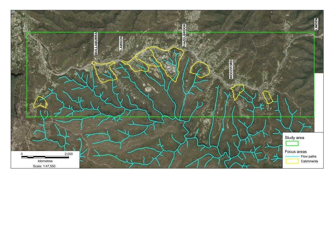
The study area is quite large, covering the townships of Bullaburra, Lawson, Hazelbrook, Woodford and Linden. There are 8 catchments that have been defined by the previous flood study, undertaken in 2012, which are the focus of the current study. These catchment areas are located south of the Great Western Highway and are shown in the map.
The objective of this study is to improve understanding of flood behaviour and impacts, and better inform management of flood risks in the study area. The study has identified and prioritised a range of flood mitigation measures to manage flood risk effectively and efficiently.
How to review the draft report
You can download the full draft Floodplain Risk Management Study and Plan here:
We welcome all feedback on the draft Bullaburra to Linden Floodplain Risk Management Study and Plan. You can submit your feedback below, or in writing to council@bmcc.nsw.gov.au
Submissions will close Friday 4th December 2020
What is the study about?
Blue Mountains City Council have engaged consultants Jacobs to undertake a floodplain risk management study and plan for the Bullaburra to Linden study area. This study and plan is now complete, and the draft report is now on public exhibition.
The study area is quite large, covering the townships of Bullaburra, Lawson, Hazelbrook, Woodford and Linden. There are 8 catchments that have been defined by the previous flood study, undertaken in 2012, which are the focus of the current study. These catchment areas are located south of the Great Western Highway and are shown in the map.
The objective of this study is to improve understanding of flood behaviour and impacts, and better inform management of flood risks in the study area. The study has identified and prioritised a range of flood mitigation measures to manage flood risk effectively and efficiently.
How to review the draft report
You can download the full draft Floodplain Risk Management Study and Plan here:
We welcome all feedback on the draft Bullaburra to Linden Floodplain Risk Management Study and Plan. You can submit your feedback below, or in writing to council@bmcc.nsw.gov.au