Bullaburra to Linden Floodplain Risk Management Study
Share Bullaburra to Linden Floodplain Risk Management Study on FacebookShare Bullaburra to Linden Floodplain Risk Management Study on TwitterShare Bullaburra to Linden Floodplain Risk Management Study on LinkedinEmail Bullaburra to Linden Floodplain Risk Management Study link
Consultation has concluded
What is the study about?
Blue Mountains City Council has recently engaged consultants Jacobs to undertake a floodplain risk management study and plan for the Bullaburra to Linden study area.
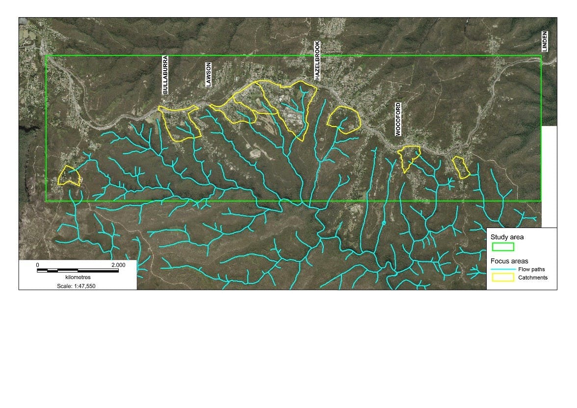
The study area is quite large, covering the townships of Bullaburra, Lawson, Hazelbrook, Woodford and Linden. There are 8 catchments that have been defined by the previous flood study, undertaken in 2012, which will be the focus of the current study. These catchment areas are located south of the Great Western Highway and are shown in the map.
The objective of this study is to improve understanding of flood behaviour and impacts, and better inform management of flood risks in the study area. It will aim to identify and prioritise a range of flood mitigation measures to manage flood risk effectively and efficiently.
While most of the development in this area is located on ridge lines adjacent to the Great Western Highway, there are areas affected by overland flows (also called flash floods) and minor flowpaths that this study will investigate. The study will undertake the following:
Update flood modelling for the area to calculate flood depth, water speed and identify high hazard zones
Identify projects such as construction works and other measures which will improve safety and protect property during floods
Assess how effective these works and measures will be at reducing flood risk
Consider the environmental, social and economic effects of the flood mitigation projects
Establish a program for implementing the most effective flood mitigation projects
Why we need your help?
Community involvement is important in all stages of the Floodplain Management Process. Resident’s local knowledge of the area and their personal experiences of flooding provide an invaluable source of data to help define the flood behaviour.
We need this information to make sure the flood models are representing what happens in real life.
These flood models will then be used to assess various flood mitigation options, so we would also like to get your suggestions on what mitigation measures might work in your area. We would ask that you would fill out the community questionnaire by 31 May 2018.
What is the study about?
Blue Mountains City Council has recently engaged consultants Jacobs to undertake a floodplain risk management study and plan for the Bullaburra to Linden study area.
The study area is quite large, covering the townships of Bullaburra, Lawson, Hazelbrook, Woodford and Linden. There are 8 catchments that have been defined by the previous flood study, undertaken in 2012, which will be the focus of the current study. These catchment areas are located south of the Great Western Highway and are shown in the map.
The objective of this study is to improve understanding of flood behaviour and impacts, and better inform management of flood risks in the study area. It will aim to identify and prioritise a range of flood mitigation measures to manage flood risk effectively and efficiently.
While most of the development in this area is located on ridge lines adjacent to the Great Western Highway, there are areas affected by overland flows (also called flash floods) and minor flowpaths that this study will investigate. The study will undertake the following:
Update flood modelling for the area to calculate flood depth, water speed and identify high hazard zones
Identify projects such as construction works and other measures which will improve safety and protect property during floods
Assess how effective these works and measures will be at reducing flood risk
Consider the environmental, social and economic effects of the flood mitigation projects
Establish a program for implementing the most effective flood mitigation projects
Why we need your help?
Community involvement is important in all stages of the Floodplain Management Process. Resident’s local knowledge of the area and their personal experiences of flooding provide an invaluable source of data to help define the flood behaviour.
We need this information to make sure the flood models are representing what happens in real life.
These flood models will then be used to assess various flood mitigation options, so we would also like to get your suggestions on what mitigation measures might work in your area. We would ask that you would fill out the community questionnaire by 31 May 2018.
Share Community Questionnaire on FacebookShare Community Questionnaire on TwitterShare Community Questionnaire on LinkedinEmail Community Questionnaire link